Big Trout, Adaminaby
[ < < previous | index ]
Wanting to get an early start for a full day on the road, we rose at 07:00 for breakfast and packing the car. The day had dawned grey and rainy, with sheets of water falling from the sky and thick fog enveloping the upper reaches of the mountain outside our balcony door. It seems we've been fortunate to have relatively good weather for the three days we stayed in Thredbo, book-ended by pouring rain on the driving days. We didn't rush too much, and by the time we'd dropped the keys off at the Alpine Hotel to check out and were underway, it was around 08:15.
We drove north through Jindabyne and Berridale, then took a left turn on to the less well-travelled road to Adaminaby. This was a narrower road, with no shoulder to speak of outside the thin vehicle lanes. Thankfully there was little traffic; I think three cars passed us going the other way by the time we had covered the 57 km to Adaminaby.
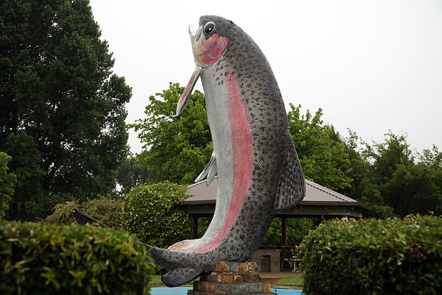
Adaminaby is famous for the Big Trout. Not just big, but in fact the "biggest trout in the world" according to the legend on our road map. Towering 16 metres above the fountain in which it is installed (which was dry, except for the current slicking of rain), this monstrous trout statue just goes to prove Qui-Gon Jinn's mantra: There's always a bigger fish. We stopped for some photos, which were made tricky by the heavy rain, then did a quick walk around the small set of shops which were set around a grassed public square area. We bought some water and Michelle got a coffee.
Big Trout, Adaminaby |
I made the egregious mistake of commenting to a local about the poor weather, and he immediately said that it was the best weather they'd had for ages. Everyone was really enjoying the rain, and he hoped it stayed like this for the next week or so. As we walked along the street front to peruse what other shops were there, we passed other people. One woman was crossing the path of a man, and she said, "Lovely weather, isn't it?" To which he replied enthusiastically, "Yep!"
Before leaving Adaminaby, we topped up with petrol, having a fair way to go through the Kosciuszko National Park again before emerging at another town and the next opportunity to fill up. We headed into the park along the road to Tumut, which climbed continuously for several kilometres before topping out at around 1400 metres as indicated by road signs. The vegetation changed from the lowland grassy sheep and cattle paddocks scattered with big gum trees into snowgum forest and then rolling hills of tussock grass dotted with granite boulders and the occasional trees. About halfway through the park, we arrived at the abandoned gold mining settlement of Kiandra, where the remnants of houses stood silent witness to the activities of the past.
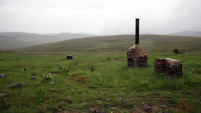 Remains of abandoned house, Kiandra |
In the middle of the national park we reached the turnoff for Yarrangobilly Caves. A 6 km gravel road led downhill to the visitor information centre and the entrances to the caves. We'd arrived just after 11:00, missing the first guided tour of the day, and the next wasn't until 13:00 - too late for us to stay. But fortunately there is also a cave which you can walk through without a guide. We paid the entrance fee and set out on the 500 metre walk to Glory Arch, which forms the entrance to North and South Glory Caves. North Glory Cave is the one open for self-guided tours, so we entered and took our time wandering through it, admiring the limestone formations and rockfalls within. The rain was penetrating the porous rock and dripping from many places on the ceiling. We had to sidestep puddles and dodge or dash through heavy drips in many places. But in a way it was good to see the cave so wet, as water is the force that creates the subterranean wonders of such places.
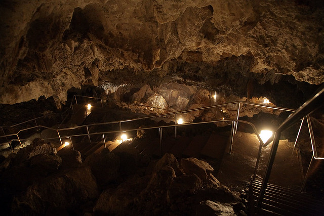 North Glory Cave, Yarrangobilly Caves |
It took us a good 45 minutes or so to walk through the cave. The air was damp and very cold inside. At one place, torrents of water poured out of holes in the ceiling, splashing loudly on to a limestone pan below, where you could see the ripples carved into the rock by the force of the water. Eventually we emerged through a steel door, not far from where we had parked the car. The rain had stopped while we were inside the cave.
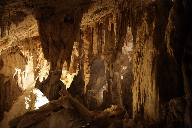 North Glory Cave, Yarrangobilly Caves |
We ate a quick lunch of sandwiches we'd prepared in the morning before leavin Thredbo. Michelle had Vegemite, while I had ham and cheese. Then we headed back up the dirt road to the highway and continued the long haul drive to Tumut.
Tumut was a much bigger town than I had expected. There was even a traffic light on the main street! We stopped to stretch our legs and have a bit of a look around. I took several photos of historic old buildings along the main street, which came in two distinct styles: timber with corrugated iron rooves and wrought iron lacework balconies as typified by the pubs, and monumental stone with numerous arches and square blocky columns belonging to the post office and banks.
From Tumut it was a short drive to Gundagai, where we joined the Hume Highway north to Sydney, and the columns of traffic that ply this main route. The freeway offered a significant increase in speed over the roads we'd been travelling on, at the cost of interesting scenery. We stopped in Yass for a rest break, then ploughed on, past the Goulburn bypass and ever northwards.
Just before Berrima, we took the right turn on to the Illawarra Highway, which cuts across the mountains from the Hume Highway to the coast just south of Wollongong. I'd never travelled on this road before, and the thought of seeing something new appealed immensely more than the dreary old drag north into Sydney on the bland freeway of the Hume. Immediately we turned on to the new road, it was clear we'd done a good thing, as it wended its way thorough scenic grazing land at a more leisurely pace.
After passing through the towns of Moss Vale (where we stopped for a toilet break) and Robertson, the road entered Macquarie Pass National Park, thick with forest, and with fog. We slowed down to a crawl as pea soup enveloped the road so closely that we could only see a few metres ahead. It didn't last long, a we crested a hill and began the long, slow descent down Macquarie Pass. This road was amazing, with dozens of tight hairpin bends on the steep downhill gradient, surrounded by thick forest emerging from a moist ground cover of ferns and bushes. The fog coiled around and through the trees, lending the scene an unreal, eerie feel.
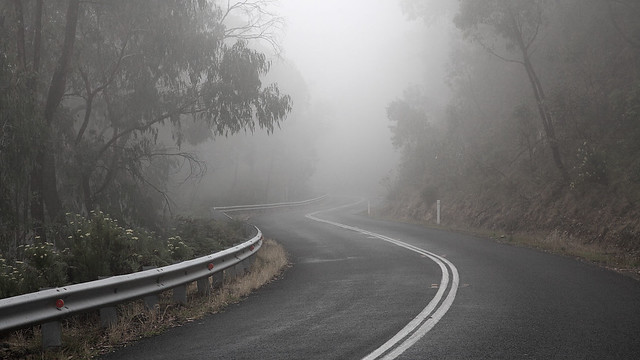 Macquarie Pass |
At the bottom of the hill we emerged from the forest and on to farming plain, a short distance from Albion Park and the coastal freeway north into Sydney. From here it was the mere matter of twenty minutes of driving before we hit the southern suburbs.
We stopped in Engadine for dinner, as it was by now getting on to 20:00. The Engadine shops are large and sprawling, covering several blocks of the centre of the suburb. We located a cheap and cheerful Indian diner, where Michelle had rice and lentil dhal with aloo paratha, and I had vegetable korma and lamb curry plus a samosa. The food was reasonable, and we scoffed it down in a hurry as we were hungry from the lengthy road trip. We then bought some milk for breakfast in the morning and drove the rest of the way home through the suburbs to complete our journey.
[ < < previous | index ]